Bad things happen to people who get lost in the wilderness. People write hundreds of blog posts every year about what to do in case you get lost in the wilderness. In this post I’m going to show you how NOT to get lost in the forest.
Pride and hubris are dangerous things in the woods because neither one will point north or tastes good cooked in the stew pot, so leave them at home and bring a map and compass instead. Many times in the woods there’s no cell signal so using your phone isn’t an option. Your batteries could run out or you could fall into the water on a river crossing thus causing your electronics to stop working.
There are different ways to navigate and this being the golden age of electronics people love their Google maps, GPS units, and hunting apps for figuring out where they are. These are all great ways and usually they are pretty accurate. (I looked at my phone once and it showed me in a different county about fifteen miles from where I really was.) Once I saw this I decided I’d never enter the woods without a map and compass, or at least a compass, because with a compass you’ll always know which way is north.
Basic Map and Compass
You don’t have to be able to shoot a resection using a map and compass in order to get at least a little benefit from them, so let’s start with the very basics. Your compass needle always points north. If you face north and hold your right arm out to the right, that’s east. Hold your left arm out straight to the left and that’s west. Do an about face and you’ll be facing south. Pretty easy eh?
Click here to look at free topographic maps of your area.
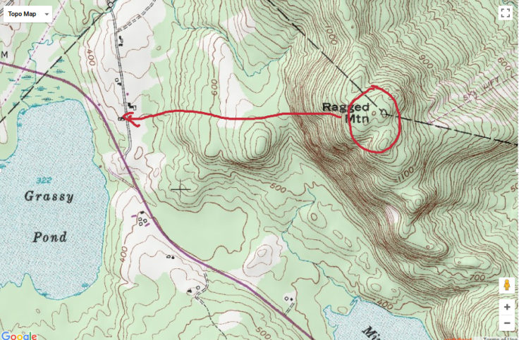
So let’s take a super high level look at a map:

The map above is a special map called a topographic map. This means that using certain techniques you can look at the map in three dimensions. The brown lines all over the map are topographic lines. You’ll see some of them labeled 500, 700, 1100, etc. These are elevation lines that tell how high a hill or mountain is. Just below and to the right of Ragged Mtn peak you’ll see 1100 with a slightly darker line. This means that this line is 1100′ in the air. The line above it is 20 feet higher etc. When lines are close together that means you’re looking at a very steep mountain (or hole in the ground) and the farther away they are from each means there’s less elevation change.
Maps are set up so that north is straight up. If north is straight up, then right is east, down is south, and left is west.
On the map above there’s a red line running to the right of Grassy Pond. This is a road. We now have enough information so that if we were to climb Ragged Mountain with just a compass and we wandered off the trail and got lost we could still find our way back to civilization.
No matter where you are on Ragged Mountain, if you go west you’ll eventually hit the road. Unless you’re doing point to point land navigation like we used to do in the Corps, having this kind of rough idea can save your ass in the wilderness. We call this using a handrail, which means you have something that borders the area you’ll be hiking in. You could also use a river, a mountain range, highway, or anything that goes the entire length of the are where you’ll be hiking.
Compass

At the “front” of the compass is the Direction of Travel Arrow. Wherever that arrow points is where you want to go. The compass is currently set up to travel north. The red N needs to line up inside the blue circle.

In the picture above the green line is on 270 degrees, which is west, and the red N is inside the blue circle. If you follow the direction of travel arrow you will be walking west.
There is a whole lot more to land navigation of course. This technique is simply to get you walking in one direction until you run into your handrail (road, river, mountain range, etc) so that you find your way back to civilization.
So there you have it. A very simple technique to keep yourself from getting lost in the woods as long as you have a compass. Even using a little button compass all you have to do it let the arrow point north and then walk towards the W, which is west.
Questions? Comments?
Sound off below!
-Bob Augustine
aka Jarhead Survivor

Well done.I’m new to the “survival” community but have been one a while.land nav. Is a big thing w me.because I’m trying to learn.I appreciate your direct no b.s. advise thank you
LikeLike
Thanks for reading! I intend to put more posts on here about map reading, so stay tuned. I also have Youtube channel that shows some more map reading if you’re interested. Here’s one on how to read an azimuth. Similar to this post, but a trifle more detail: https://www.youtube.com/watch?v=on7E9eCSHMI
LikeLike